
Drone Land Surveying for Stockpile Volumes on Quarry and Material Sites
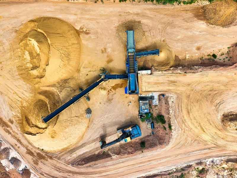
Guessing at stockpile volumes costs money. A pile can look the same size for months. But it can shrink or grow by hundreds of cubic yards and no one notices. For quarry operators and material yards, that gap shows up in inventory reports, royalty numbers and audits.
Drone land surveying fixes this problem. It measures stockpiles with far more detail than ground methods can offer. One short flight captures the whole pile. That data turns into a volume number you can trust. This article explains how the process works, what affects accuracy and how to use the results to run a tighter site.
How Drone Surveys Measure Stockpile Volumes
A drone survey measures a stockpile by taking many overlapping photos from the air. A flight can capture hundreds or even thousands of images. Software then stitches these photos into a 3D model. A surveyor uses that model to calculate volume.
Here is how the process usually works:
- The drone flies a set flight path over the site
- Cameras take photos with heavy overlap, often 70 to 80 percent
- Software builds a 3D surface from the photos
- A surveyor compares the pile surface to the ground surface below it
- Volume comes from the difference between those two surfaces
This method beats older ways of measuring, like walking a pile with a GPS rover. A rover only checks a few points on the pile. It misses odd shapes and uneven spots. A drone covers the entire surface. The volume reflects the real shape of the pile, not a guess based on a few readings.
This matters at every stage of a working quarry. Crushed stone, sand, gravel and overburden piles all change shape as crews add or remove material. Drone surveys keep up with that pace. Crews don’t need to stop work for hours to get a measurement.
Why Stockpile Shape Affects Volume Accuracy
The shape of a pile has a big effect on how accurate the volume number will be. Piles with steep sides, overhangs or uneven bases are harder to measure than flat, even piles.
A cone-shaped pile with a clean base is simple to measure. A pile pushed against a wall, mixed with different materials, or shaped by loader traffic is much harder to model. Steep sides can create shadows in the photos. Overhangs can trick the software into missing material tucked underneath an edge.
Surveyors plan around these problems. They fly at the right height and speed for the shape of the pile. They adjust how much the photos overlap. They also check the finished model against known points on the ground. A tall pile with sharp edges needs tighter flight lines than a low, spread-out pile.
Site conditions matter too. Dust, wet ground and moving equipment near the pile can all hurt photo quality during a flight. A good survey plan accounts for these issues before the flight, not after.
Establishing Reliable Ground Control for Quarry Mapping
Ground control points are fixed spots on the ground with known coordinates. Surveyors use them to anchor the drone data to real-world locations. Without them, a drone model can look sharp but sit in the wrong spot or at the wrong height.
For quarry and material site mapping, ground control should:
- Spread out around the whole survey area, not just near the stockpiles
- Cover changes in elevation across the site
- Tie to a known coordinate system and elevation standard
- Stay in place, or get re-checked, for every repeat flight
Sits on a mix of land. Areas east of the city are flatter. Land near the Hill Country to the west is more rugged. Quarry sites in these hillier areas often have big elevation changes over short distances. That makes strong ground control even more important. A model built on weak or uneven control points can produce a volume number that looks fine but is off by a real amount.
Some surveyors use GPS base stations or network corrections instead of, or along with, traditional ground points. Both methods work. But the site needs one method used the same way every time.
Tracking Material Changes Between Drone Survey Flights
Comparing two drone surveys shows exactly how much material a site gained or lost. This is where drone surveys become more than a single snapshot. They become a real tracking tool over time.
To get accurate change data, each flight needs to match the last one. Same ground control. Same coordinate system. Similar flight pattern. Small setup differences between flights can create errors that look like real material change but are not.
Once a surveyor compares two flights, the software builds a cut-and-fill map. It shows where material was added, where it was removed and how much changed. This works well for:
- Monthly or quarterly inventory checks
- Royalty payments based on material removed
- Tracking overburden removal against a permit
- Checking contractor output against reported totals
A steady flight schedule, whether monthly, quarterly or tied to production, gives operators a real record over time. That beats relying on a single measurement taken once.
Using Stockpile Survey Data for Site Operations
Stockpile data does more than count inventory. It feeds planning, reporting and daily decisions that affect the bottom line of a quarry or material site.
Operators use this data to:
- Match physical inventory against accounting records
- Support royalty and lease payment math
- Track material loss from shrinkage, spillage or erosion
- Plan haul routes and equipment based on where piles sit
- Provide records for permit checks or audits
A drone survey captures the whole site in one flight. That same data can also map drainage patterns, haul road condition and boundary lines near the extraction area. One accurate dataset can serve several needs instead of separate, disconnected measurements.
Sites growing suburban edge see steady demand for material as construction and development continue. Accurate stockpile tracking helps operators respond fast to buyer requests and plan production without guessing at what they have on hand.
